Trekkers

  • Subscribe to our RSS feed.
  • Twitter
  • StumbleUpon
  • Reddit
  • Facebook
  • Digg

Monday, 19 May 2008

Climate change in our world

Posted on 02:00 by Unknown
Posted by Ed Parsons, Geospatial Technologist and Phil Verney, Google Earth Community Development

Of the challenges surrounding global climate change, communicating its potential impact and increasing public awareness of the scientific research undertaken to monitor and model its effect on society are quite pressing.

Today we are pleased that the British Government is launching with Google Earth Outreach, and in collaboration with the Met Office Hadley Centre and the British Antarctic Survey, new layers in Google Earth that utilize geographical information to show how climate change will affect our planet and its people.

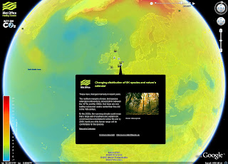
The Met Office Hadley Centre has produced a layer which illustrates their future temperature modeling, showing an animation of temperature change over the next hundred years and its impact to particular parts of the world.

The scientists of the British Antarctic Survey have developed a layer which details how they monitor and measure the effects of climate change in Antarctica, featuring stunning images that show the retreat of the ice from this environmentally-sensitive continent.

Featured on our Google Earth Outreach Showcase, which provides more than 100 examples of KML content telling stories about our planet, are these two layers:
Climate Change in Our World and Climate Change in Our World, Antarctica. These two KML files offer a unique distillation of informed, scientific and geographically-organized information demonstrating the commitment by the British Government to continue to carry out this important climate research and to communicate the results of the research by making this information readily accessible.


Update (5/20, 4pm): You can view Prime Minister Brown's announcement of this initiative:

Email ThisBlogThis!Share to XShare to Facebook
Posted in Outreach | No comments
Newer Post Older Post Home

0 comments:

Post a Comment

Subscribe to: Post Comments (Atom)

Popular Posts

  • Tracking Santa: the backstory
    [Cross-posted with the Official Google Blog ] When I look back on four years of tracking Old St. Nick on Christmas Eve, I can't help but...
  • Diving into the Great Barrier Reef
    [Cross-posted from the Official Google Australia Blog ] Australia is home to many geographical treasures, and the Great Barrier Reef has to ...
  • Imagery for Myanmar (Burma)
    Posted by Matt Manolides, GIS Specialist; Dylan Lorimer, Strategic Partner Manager; and Chikai Ohazama, Product Manager In the aftermath of ...
  • Don't forget: Academic Developers Conference
    A  reminder  to all of you interested in cutting edge applications for Google Earth and Google  Maps: Google is co-sponsoring a conference w...
  • More transit agencies get on board
    Summer is my favorite season. It's warm and sunny, there's plenty of fresh fruit as a treat for my sweet tooth, all the extra daylig...
  • A fitting send-off
    Posted by Andy Connolly, Visiting Faculty, University of Washington As Stefan Geens noted on Ogle Earth , the sky can provide real fireworks...
  • New Rumsey Historical Maps and new ways to view them
    Posted by David Rumsey, Founder, David Rumsey Map Collection With the recent addition of over 100 new historical maps, there are now 120 map...
  • Organizing more than one world's information
    Posted by Michael Weiss-Malik, Software Engineer We like to think big. Vastly hugely mind-bogglingly big (to paraphrase one of my favorite ...
  • A new place to find help
    Our Google Map Help Group now has a new home! You may have already heard of (or tried out) the  new Google Help Forums . Today, our  Google ...
  • Helpful maps for the Inauguration
    There is most definitely a buzz in the air.  Hundreds of thousands of people are streaming into Washington D.C. to see Barack Obama sworn in...

Categories

  • gadgets
  • Map Maker
  • Mobile
  • Outreach
  • Quiz
  • real estate
  • Street View
  • Tip of the week
  • Transit

Blog Archive

  • ►  2009 (11)
    • ►  January (11)
  • ▼  2008 (257)
    • ►  December (17)
    • ►  November (16)
    • ►  October (27)
    • ►  September (33)
    • ►  August (16)
    • ►  July (20)
    • ►  June (17)
    • ▼  May (25)
      • European Football Championship 2008 - Google Fan Map!
      • Google Earth, meet the browser
      • Map of Santa Cruz Mountains wildfire
      • In their own words
      • Getting scientific with Google Earth
      • Extra! Extra! Discover the world's news in Google...
      • Panoramio gathering in London
      • Climate change in our world
      • Imagery for Sichuan, China Earthquake
      • Myanmar maps update
      • News flash: Maps now open to Flash developers
      • Explore places with photos, videos, and more
      • More ways to find more than ever
      • Where in the world is... (Answers)
      • Where in the world is...
      • Street View revisits Manhattan
      • New Rumsey Historical Maps and new ways to view them
      • Master collection of Cyclone Nargis layers
      • AC Transit schedules now available in Google Maps
      • Using Google Earth to inform cyclone response
      • Imagery for Myanmar (Burma)
      • Tracking the path of Cyclone Nargis
      • Three cheers for teachers
      • Google Earth layer of Myanmar cyclone data
      • Mapped web pages in Google Maps
    • ►  April (30)
    • ►  March (16)
    • ►  February (25)
    • ►  January (15)
  • ►  2007 (137)
    • ►  December (19)
    • ►  November (27)
    • ►  October (26)
    • ►  September (13)
    • ►  August (14)
    • ►  July (13)
    • ►  June (11)
    • ►  May (14)
Powered by Blogger.

About Me

Unknown
View my complete profile