Trekkers

  • Subscribe to our RSS feed.
  • Twitter
  • StumbleUpon
  • Reddit
  • Facebook
  • Digg

Wednesday, 31 October 2007

More languages in 3D Warehouse

Posted on 16:18 by Unknown
Posted by Lori Meiskey, Software Engineer

If you've had a chance to stop by the Google SketchUp Blog today, you most likely saw my post heralding the release of 3D Warehouse in eight new languages. Now Portuguese, Dutch, Russian, Polish, Korean, Arabic, Czech, and Traditional Chinese join our list of available translations. Already included are English, French, German, Italian, Japanese and Spanish.


We're hoping the release of Google 3D Warehouse in these additional languages will encourage folks across the globe to contribute sketches. I'm certainly looking forward to seeing all of your work!


For more information about getting started, take a look at this 3D Warehouse overview.
Read More
Posted in | No comments

Earthquake mapping

Posted on 13:20 by Unknown
Posted by Lior Ron, Product Manager, Google Maps

I was working kind of late last night, and around 8:04 pm, I felt the floor underneath my desk shake and move. For a second I thought the Google Halloween party was getting wild, but then I realized I was experiencing my first earthquake!

Equipped with my mapping skills, I went to explore what exactly happened. I found some cool things about the earthquake by using Google Maps, and I thought I would pass this info along to you:

Where did it happen?
A search through user-generated content on Google Maps quickly provided the answer. Many of our My Maps users created maps pointing to the center of the earthquake minutes after it happened. To access this data, search for "Alum Rock Earthquake" scroll down the search results, and click on "see more community maps."

Add earthquakes to your map:
I didn't think our post from the folks at the U.S. Geological Survey would come in handy quite so soon! Their Earthquake Mapplet shows all of the earthquakes that have taken place throughout the world in the last week. Click on the "Save to My Maps" link to customize your My Maps tab and include earthquake data.

Explore earthquakes in Google Earth:
A 3D view of earthquakes is very useful to understand their impact. If you have Google Earth installed, check out this Earthquake KML from USGS. Fly to San Jose, click on the big orange circle, and choose "View ShakeMap" link to see the full impact of the earthquake.
Read More
Posted in | No comments

Map of the day: Halloween edition

Posted on 09:17 by Unknown
Posted by Jess Lee, Product Manager, Google Maps

Happy Halloween from the Google Maps team! If you're looking for local costume parties or haunted houses, here are some Halloween event maps for different cities in the U.S.:

Portland corn mazes and pumpkin patches - A guide to Portland, Oregon metro-area corn mazes, pumpkin patches and fall harvest events, created by the Oregonian News.

Chicago's Haunted Houses - Best places for a scare in the Windy City.

Halloween Happenings in Detroit - Fun events for the entire family throughout the month of October, created by MyFoxDetroit.com.

Where the Scares Are, LA 2007 - A map to month-long haunted attractions throughout greater Los Angeles, created by CreepyLA.com.

OC Halloween Events - The top Halloween attractions, events, and entertainment in Orange County, including Disneyland, Knott’s Scary Farm, haunted houses, Halloween balls and more.

Halloween in Tampa Bay - All of Tampa Bay's spooky events.
Read More
Posted in | No comments

Thursday, 25 October 2007

Master layer for Southern California fires imagery

Posted on 14:40 by Unknown
Posted by Wei Luo, Senior GIS Specialist

We have created a master layer in Google Earth that includes all of the imagery of the affected areas that we've published so far. The new layer includes imagery from MODIS (from 10/24) as well as updated fire perimeters from the San Diego EOC. And we'll incorporate new imagery as it becomes available.

Be sure to save the KML file to "My Places" by right-clicking and choosing "Save to My Places." To get the latest updates, right-click on the KML file in "My Places" and then choose "Refresh."

Update (4:15, 10/26): We've incorporated infrared SPOT-5 satellite imagery from Spot Image Corporation and new data from NASA and the San Diego Emergency Operations Center into the master layer.


Image (c) CNES 2007 / SPOT Image Corporation
Read More
Posted in | No comments

Wednesday, 24 October 2007

Southern California fire imagery

Posted on 16:02 by Unknown
Posted by Wei Luo, Senior GIS Specialist

As the fires in Southern California continue to spread, our data providers have gathered updated imagery of the affected areas. We are making this imagery taken on October 22nd available as a Google Earth overlay, and will continue to update the imagery as it becomes available. Our thoughts are with the communities displaced by this tragedy.

Thanks to DigitalGlobe for their fast work.


Image (c) 2007 DigitalGlobe

Update (9:02 PM): Thanks to NASA and the US Forest Service, overlays of the fire perimeters and thermal infrared imagery, both captured today, are now viewable in Google Earth.


Update (12:40 AM): The San Diego Regional Emergency Operations Center has provided us with valuable information including fire perimeters, mandatory evacuation areas and re-opened areas.

If you have not yet downloaded Google Earth, you can do so here.
Read More
Posted in | No comments

Where in the world is ... (bonus edition -- Answers)

Posted on 09:32 by Unknown
Posted by Matt Manolides, GIS Specialist

Great job, everyone! I love following your collective blog entries tracking the updates, especially the ones that find updated imagery totally unrelated to the hints I gave.

Answers:
1) U.S. Route 91 turns into a much more famous stretch of road when it crosses into this town.
-- Las Vegas (The Las Vegas Strip)


2) Every year, this city plays host to the U.K.'s largest outdoor (temporary) ice rink.
-- Leeds, England (The Ice Cube)

3) Paradise: In this town you can surf or visit the world's most delicious book store, located in
an old Twinkie factory (with plenty of aging filling still in the pipes).
-- Cleveland (Anyone who watches "Anthony Bourdain: No Reservations" should have gotten that one right!)

4) The original name of this city was Terminus.
-- Atlanta, Georgia

5) The world's northernmost opera house is located in this town.
-- Umeå, Sweden

6) This major U.S. city is actually north of Canada.
-- Detroit, Michigan

7) A popular children's game show that promoted geographic knowledge was produced out of
this city.
-- Pittsburgh (Where in the World is Carmen Sandiego?)

8) Don't let the name fool you -- this lake actually fills a 4,000ft deep caldera.
-- Crater Lake, Oregon

9) You can tour the Royal Navy's first iron-hulled, armor-plated warship in this town.
-- Portsmouth, England (HMS Warrior)


10) The historic fort in this city was restored based on an 1847 map published in Darmstadt,
Germany.
-- Sacramento (Sutter's Fort)


11) As Halloween approaches, one might be interested in viewing the 'Ghost Capital of Britain.'
-- Derby, England

12) Now part of Germany, this city was once the capital of the Hanseatic League.
-- Luebeck, Germany

13) President Lincoln attended the dedication ceremony of the Soldier's National Cemetery in
this town.
-- Gettysburg, PA (President Lincoln gave the Gettysburg Address at this dedication ceremony.)


Here's a more complete list of imagery updates in this data push:


New high resolution:
Americas: State of Oregon, State of Nebraska, State of North Carolina,
Western Mississippi, Much of Pennsylvania, Yakima County (WA),
Benton County (WA), Whistler (BC), San Jose (CA), Imperial County (CA),
Steamboat Springs (CO), Calhoun County (FL), Adams County (IL),
Washtenaw County (MI), Chemung County (NY), Cortland County (NY),
Castilla (Colombia)

Europe, Middle East & Africa:
- France: French Riviera, Avignon
- UK: Exeter, Brighton, Crawley, Essex, Colchester, Chelmsford,
Swindon, Cheltenham, Ipswich, Norwich, Peterborough, Leicester,
Chesterfield
- Germany: Freiburg, Stuttgart, Waiblingen, Remseck, Kornwestheim,
Ludwigsburg, Saarbruecken, Chemnitz, Erfurt, Ratigen,
Munster, Hamburg, Luebeck
Umea (Sweden)
Borger-Odoorn (The Netherlands)

2.5m imagery for the entire countries of: Tunisia, UAE, Jordan, Syria, Lebanon, and Israel.


Updated Imagery:
Americas: Las Vegas (NV), San Francisco Bay Area (East Bay & North Bay),
Sacramento (CA), Victoria (BC), Salt Lake City (UT), Provo (UT), Edmonton (Alberta),
Atlanta (GA), Northern St Louis (MO), Detroit (MI), Cleveland (OH), Pittsburgh (PA),
Boston (MA), Montreal (Quebec), Guadalajara (MX), Buenos Aires (Argentina),
Belo Horizonte (Brazil), Fortaleza (Brazil), Montevideo (Uruguay)

Europe, Middle East & Africa:
- UK:
Plymouth, Torquay, Bournemouth, Southampton, Portsmouth, Gillingham
Southend, Basildon, Berkshire, Reading, Milton Keynes, Newport, Cardiff,
Swansea, Cambridge, Norfolk, Derby, Halifax, Leeds, Darlington, Dundee,
Belfast
Warsaw (Poland), Stockholm (Sweden), Lippstadt (Germany), Magdeburg (Germany),
Paderborn (Germany), Rostock (Germany), Boeblingen (Germany), Casablanca (Morocco),
Bamako (Mali), Windhoek (Namibia), Ankara (Turkey), Kano (Nigeria)

Asia & Oceania: Novosibirsk (Russia), Tashkent (Uzbekistan), Ahmendabad (India),
Pune (India), Bangalore (India), Hyderabad (India), Perth (Australia), Brisbane (Australia)
Ulan Bator (Mongolia),

Updated Terrain:
Canada (20m and 90m) and Niagara Falls
Read More
Posted in Quiz | No comments

Tuesday, 23 October 2007

Where in the world is ... (bonus edition)

Posted on 13:25 by Unknown
Posted by Matt Manolides, GIS Specialist

Surprise! I bet you weren't expecting another imagery update from the Google Earth/Maps team so quickly. ;-)

I'm very happy to announce that, today, we've published a large amount of new high-res imagery around the world. While in the previous post I spoke of 60cm imagery, this release has mostly aerial (higher-resolution) data, as well as some medium-resolution imagery for large swaths of land. Some of you were able to solve the last quiz within a few hours of posting it, so I'm going to throw in some more challenging clues this time around.

1) U.S. Route 91 turns into a much more famous stretch of road when it crosses into this town.
2) Every year, this city plays host to the U.K.'s largest outdoor (temporary) ice rink.
3) Paradise: In this town you can surf or visit the world's most delicious book store, located in
an old Twinkie factory (with plenty of aging filling still in the pipes).
4) The original name of this city was Terminus.
5) The world's northernmost opera house is located in this town.
6) This major U.S. city is actually north of Canada.
7) A popular children's game show that promoted geographic knowledge was produced out of
this city.
8) Don't let the name fool you -- this lake actually fills a 4,000ft deep caldera.
9) You can tour the Royal Navy's first iron-hulled, armor-plated warship in this town.
10) The historic fort in this city was restored based on an 1847 map published in Darmstadt,
Germany.
11) As Halloween approaches, one might be interested in viewing the 'Ghost Capital of Britain.'
12) Now part of Germany, this city was once the capital of the Hanseatic League.
13) President Lincoln attended the dedication ceremony of the Soldier's National Cemetery in
this town.


I'll post the answers to these clues in a few days. Good luck, everyone!

As a teaser, here's what our new Niagara Falls image looks like...


Read More
Posted in Quiz | No comments

Monday, 22 October 2007

San Diego Fire Map

Posted on 13:57 by Unknown
Posted by Jess Lee, Product Manager, Google Maps

For those of you affected by the two wildfires in San Diego County, KPBS Online created a fire map that includes up-to-date news on the spread of the fire and shows the location of evacuated areas, Red Cross evacuation centers, and closed highways. They are also providing live radio coverage of the fire.


The Los Angeles Times is also tracking fires across Southern California in a map, found here.

Update: We've posted an updated list of fire maps and other information on the Official Google Blog.
Read More
Posted in | No comments

Friday, 19 October 2007

Recap of Google's International Cleanup Weekend

Posted on 13:55 by Unknown
Posted by Steve Miller, Google Earth Outreach

Well, the numbers are officially in for International Cleanup Weekend. When the dust settled, we looked at the map and found that cleanups were planned in 35 countries, involving over 3,000 participants in almost 300 cleanup projects. Now that's a lot of trash and a lot of cleaning up.

When we started crafting our plans, we expected to see cleanups in the 15 countries where the 'My Maps' tab in Google Maps is available. We were pleased -- and surprised -- to find cleanups in many more countries than that, and even one that took place underwater. Our thanks go out to the 41 environmental organizations around the world that joined the cause, and to the United Nations Environment Programme.

And our biggest thank you goes out to everyone who participated. We know that picking up trash isn't the most exciting thing to do with your weekend, but you can give yourself a pat on the back for helping to make a difference. Of course, we also hope that your efforts won't end with this project. Whether or not you organized a cleanup last weekend, we hope you'll consider making a map for another project that will make a difference close to home. Remember, changing the world starts with you.

Take a peek at some of our favorite cleanup projects from the weekend, all created within Google Maps:


Read More
Posted in Outreach | No comments

Wednesday, 17 October 2007

Put yourself on the map

Posted on 09:07 by Unknown
Posted by Jess Lee, Google Maps Product Manager

Who knows your neighborhood better than you? That's why we've been releasing features that let you add your own content to Google Maps. For example, you can use our map-creation tools to make maps of recommended places to visit or leave ratings and reviews for your favorite restaurants. Your maps and reviews will be seen by the millions of people who use Google Maps every day.

Starting today, you can find out more information about the people behind these contributions through their user profile pages. For example, if you stumble upon a cool map of a bike route, you can hover over the creator's nickname and see a snippet of information about them.


If you click on their name, you'll see their profile page, which includes links to all the content that they have authored on Google Maps, including the maps they've created and the reviews they've written. If you liked the bike route you were looking at, chances are they mapped out some other cool bike routes as well.


To create your own profile, simply sign in to Google Maps and click on the My Profile link in upper right hand corner.


If we haven't convinced you yet, check out this cool video we put together outlining how to work on your own personal profile today!


Read More
Posted in | No comments

Tuesday, 16 October 2007

Raising the limits for KML on Maps

Posted on 16:42 by Unknown
Posted by Nigel Tao, Software Engineer, Google Maps

There's so much of the world to see, and sometimes it just doesn't all fit onto a map at once. Previously, people have written custom Mapplets or Maps API pages to visualize their dense geographic databases, and that's still what we'd recommend if you are a web developer and want the full interactivity of JavaScript. If you don't need that functionality, however, Google Maps now offers a better view of KML files of similar density and richness, especially when they contain <NetworkLink>s whose servers' results are tailored to the part of the world that is in view. For example:

  • The photos from our friends at Panoramio can be viewed via the same KML file you could use in Google Earth, or
  • you can watch the Wikipedia articles added to Placeopedia, or similarly see the areas noted in Wikimapia, or
  • browse the volcanoes of the world, courtesy of the Smithsonian Institution, or
  • pick from Travel and Leisure's top 500 hotels of the world.

If you like these examples, try the 'Save to My Maps' link, just under the 'My Maps' tab, to keep them around so you can do things like view Panoramio photos while searching for hotels near a potential holiday destination.
Read More
Posted in | No comments

Map of the day: Celeb spotting in New York City

Posted on 12:58 by Unknown
Posted by Larry Greenfield, Software Engineer

I know this isn't the kind of star gazing we usually report on around here, but for those of you who follow celebrity gossip, here's your chance to spot celebrities in real life. Top 50 Places to See Celebrities in NYC is a user-created map that lists all the hottest restaurants, clubs, bars and hotels in New York where you're most likely to run into celebrities like Nicole Richie, Jay-Z, J.Lo, Paris Hilton and Bruce Willis. For example, the Tribeca Grill is owned by Robert DeNiro and is frequented by his actor pals like James Gandolfini. Meg Ryan gets her famous shag haircut at the Sally Hershberger salon. And I think I once saw Julianne Moore at French bistro Pastis, which is right near the Google office.

For more examples of celebrity sightings on Google Maps, try searching for [celebrity sightings in New York]. Click on 'See community maps' to see more user-created maps.
Read More
Posted in | No comments

Monday, 15 October 2007

International Cleaner-Uppers: Show us your rubbish!

Posted on 14:45 by Unknown
Posted by Steve Miller, Google Earth Outreach

In keeping with the environmental theme of the day, we're happy to announce that the first International Cleanup Weekend was a success! If you participated, please remember to add photos and videos to your cleanup map. Don't forget to check back on Thursday for a full summary of the weekend's achievements.

Update:
The maps have already started rolling in. Check out this great one created by a Boulder-based Googler for inspiration.


Read More
Posted in Outreach | No comments

Bioneers and Google Earth

Posted on 08:59 by Unknown
Posted by Rebecca Moore, Manager, Google Earth Outreach

What do you get when you cross a conservation biologist with an engineer? A "bioneer," of course. The Bioneers integrate ideas and practices from many disciplines and cultures, with the broad goal of restoring the Earth and its environment. Each year since 1990, the Bioneers have brought together leading thinkers (and doers) at their annual conference to exchange ideas, foster connections and build new skills.

In honor of Blog Action Day, we're excited to announce that, this year, the Bioneers have invited the Google Earth Outreach team to lead a series of demonstrations and hands-on tutorials on Google Earth/Maps. We will be helping them understand how to visualize their important ideas and projects in the context of the real Earth, to collaborate more effectively with one another and to communicate more powerfully with citizens and decision-makers around the world.

For those of you out there who also want to "save the planet," our Google Earth Outreach site offers online resources to help you get started -- such as video tutorials, case studies, and a showcase gallery of great public-benefit Google Earth projects. Our team also staffs a help forum to answer your technical questions.

The goal of Bioneers is ambitious -- going beyond "sustainability" to the more challenging task of actual restoration of the Earth. As they comment:

Restoration addresses the premise that "sustainability" is problematic in the context of an environment that is already depleted. As Paul Hawken has noted, sustainability is simply the midpoint between destruction and restoration. The goal of Bioneers is restoration, addressing the interdependent array of economics, jobs, ecologies, cultures, and communities.

The Bioneers 2007 Conference runs from October 19-21 in San Rafael, California. We hope to see many of you there!

Update: Our presentation schedule at the conference is now online. Join us!
Read More
Posted in Outreach | No comments

Friday, 12 October 2007

Zoom in on Google Maps

Posted on 15:45 by Unknown
Posted by Chikai Ohazama, Product Manager

Remember what would happen as the Six Million Dollar Man chased after bad guys and needed a closer view of the action? The "na na na na... " sound effect would come on and then he would use his bionic eye to zoom in to see what was going on. Well, now we've given you a bionic eye on Google Maps! OK, not a literal bionic eye, as Steve Austin had. But you can zoom in even closer to areas all around the globe for a more-detailed view of all of the imagery in our database.

Here are some examples of things you can now see:


Life-size Chess Board


Elephants in Africa


Hippos in Africa

Read More
Posted in | No comments

Thursday, 11 October 2007

Explore even more with Google Earth

Posted on 18:53 by Unknown
Posted by James Macgill, Software Engineer


We're always excited to see what our users do with KML files and Google Earth -- whether it's a timeline of the history of London, a tour of the works of Claes Oldenburg, or a virtual Namibian road trip. And we're always trying to make it easy to create and share interesting geographic content.

We've introduced a new feature that lets you much more easily search, browse and discover some of the best geographic content directly within Google Earth. Once you've downloaded the latest version of Google Earth, just click the 'Add Content' button in the 'Places' panel, and you can explore our gallery of KML files that have been submitted by users. See what's popular with other Earth users by browsing the 'Popular' category, or take a look at some of our favorite files by choosing 'Featured.'

If you have a KML that you'd like to share, we'd love to include it as well. Please submit any content using this form, and we'll add it to the directory (in a few weeks) so that other people can easily find it.
Read More
Posted in | No comments

Become a Google Earth Pro Expert!

Posted on 15:34 by Unknown
Posted by James Therrien, Training Manager


A lot of people have been asking about ways they can familiarize themselves with the Google Earth Pro. Finally, we have a great set of classes to point them to.

Now, anyone interested in Google Earth Pro can sign up for a training class at one of the many course locations. For more information, check out this post on the Google SketchUp blog. And don't forget -- SketchUp training classes are offered too!

We look forward to seeing your progress.
Read More
Posted in | No comments

Now Playing: YouTube videos in Google Earth

Posted on 06:25 by Unknown
Posted by Amin Charaniya, Software Engineer, Google Earth

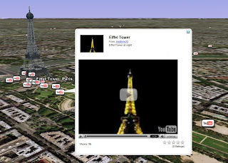
I love watching videos on YouTube. Every once in a while I'll see something so good that it makes me stop and wonder where it was recorded or how I can find more videos from that particular location. For instance, just the other day I stumbled upon a video of a man playing a guitar with his feet. The person who uploaded the video to YouTube geotagged it, so I was able to track the guitarist back to Balboa Park in San Diego, California.

Now you can find YouTube videos connected to specific locations right in Google Earth. Our new browseable layer of geotagged videos works a lot like our Google Book Search layer, only it shows you the locations referenced in specific videos instead of books. Let's say you're jetting off to Paris. Before you go, you can watch the sunset filmed from the top floor of the Eiffel Tower, among other clips of popular spots in the City of Lights.


You'll find this new layer in the 'Featured Content' folder in the left-side panel of Google Earth. Just click on the 'YouTube' button, and icons will begin to appear all over the globe. You can search for videos of your favorite places or browse videos of your dream vacation destination. More videos will appear as you zoom into a particular place. And you have the option of either playing them in Google Earth or viewing them on YouTube.

We've spent countless hours browsing these videos, and we look forward to seeing what other geotagged videos are to come. But we should warn you that if you do turn on this layer, you might not get any work done today! Take our word for it.
Read More
Posted in | No comments

Wednesday, 10 October 2007

Community maps in your search results

Posted on 10:47 by Unknown
Posted by Lior Ron, Product Manager

It's no secret that our users are the true experts on local information. Sometimes a tip from a friend or a friendly local can make all the difference.

Over the last year, we've been working hard to organize this local wisdom; we've sifted through millions of My Maps, KML files and other information created by all of you in the geoweb. Starting today, community maps will be available in search results on Google Maps. Now you can find cool places to visit, go for a hike, walk your dog, or take a date using the help of other Google users.


The blue markers ('community maps') indicate relevant user-contributed results for your search. You can click on the 'see more community maps' link either in the community box or at the bottom of the page to see more user-contributed results.

Sharing local information with other Google users is easy. You can create your own map and make it public or use KML in your Maps API site to help people find what they're looking for.


Read More
Posted in | No comments

Tuesday, 9 October 2007

More Street View cities to explore (Update)

Posted on 15:45 by Unknown
Posted by Brittany Bohnet, Associate Product Marketing Manager

As some of you may have already heard, we've added Street View imagery to six new cities in Google Maps: Chicago, Portland, Pittsburgh, Phoenix, Tucson and Philadelphia. To celebrate, we've created a new video that follows the adventures of our lovable Street View character as he karaokes his way through our newly added cities.


If you're interested in making your own Street View video, don't forget to right-click and download this
free MP3. Reply with a video response for a chance to be featured as a YouTube karaoke star! Bonus points go to those of you who have the best Street View lyrics and costume.

And if you haven't already yet, be sure to check out our new Street View additions. We think they'll have you singing in the streets, too!
Read More
Posted in | No comments

More Street View cities to explore

Posted on 05:46 by Unknown
Posted by Stephane Lafon, Software Engineer, Google Maps

For those of you who have been eagerly awaiting new cities to be added to Street View in Google Maps, your patience is about to pay off. Today, we're announcing the addition of Street View imagery in not one or two but six new cities!

Now you can check out 360-degree views of Chicago, Pittsburgh, Philadelphia, Phoenix, Portland and Tucson. As an added bonus, the images in Phoenix, Tucson and parts of Chicago are all in high resolution.

But wait! There's more. Ever wish you could pan up to the very top of a 50-story skyscraper using Street View? Well, prepare yourself for some serious sightseeing; we've introduced the ability to pan up in most new cities.

To get started, check out this incredible view of Sears Tower. (Remember to use caution if you have a fear of heights!)


Read More
Posted in | No comments

Monday, 8 October 2007

What Are You Doing This Weekend?

Posted on 08:35 by Unknown
Posted by Steve Miller, Product Manager

Last week, Google announced an International Cleanup Weekend on October 13th and 14th, encouraging Googlers and Google Maps users around the world to head out and clean up local parks, beaches, trails, and other places close to home. To date, we have received more than 130 cleanup maps from people who have enlisted the help of their friends, family members and coworkers to make the world a cleaner, better place. That brings our total to more than 1,200 people.

If you haven't yet, we hope you'll join us in our efforts this weekend and post plans of your own. All you have to do is organize a cleanup event, log into Google Maps to make a map of it, and send it to us. Remember to keep your group small (groups of 6-10 people work best) and close to home, to simplify the planning process.

As Google Maps aficionados, we know that the best maps will likely come from you. Make sure to show off your savvy map-making skills by posting photos and videos to your map! Check out this example for inspiration:

Read More
Posted in Outreach | No comments

Friday, 5 October 2007

Where in the world is... (Answers)

Posted on 09:12 by Unknown
Posted by Matt Manolides, GIS Specialist

Great job figuring out the answers to all the clues, I am always impressed at how people scattered all across the globe team up to solve these riddles.

1) I don't mean to "flatter," but this remote Northwestern cape is very beautiful.
- Cape Flattery, WA
2) You can now explore the ruins of this ancient Mayan city, first discovered in 1934.
- Becan, Mexico (it's a little cloudy, but you can still see plenty of ruins)


3) This small Peruvian village attracts many tourists each year for the Incan ruins atop nearby hills.
- Pisac, Peru
4) This city claims to be the southernmost city in the world, with approximately 64,000 residents.
- Ushuaia, Agentina
5) Home of the Russian Pacific Fleet, this city is also Russia's largest Pacific coast harbor.
- Vladivostock, Russia


6) Named after Saint Irene, though sometimes referred to as Thera, this island is a popular Greek tourist destination.
- Santorini, Greece

7) The Trojan horse from the 2004 movie Troy is visible in this city.
- Çanakkale, Turkey


8) This city is the second most populated metropolitan area in Africa, second to Cairo.
- Lagos, Nigeria
9) For better or for worse, the testing done at this site changed the world forever. In 1965 it was declared a U.S. National Historic Landmark.
- Trinity Site, White Sands Missile Range - New Mexico
10) Odessos was the original name of this large city, then a trading colony.
- Varna, Bulgaria
11) This was the first port on the Shandong peninsula to be opened to the west in the 1800s.
- Penglai City, China


Remember, this was only a small sampling, there's lots of new imagery out there to discover.
Read More
Posted in Quiz | No comments

Thursday, 4 October 2007

Now Playing: The Google Maps Video Tour

Posted on 08:40 by Unknown
Posted by Jess Lee, Product Manager, Google Maps

Over the past few months we've put together some fun YouTube videos to help educate people about features in Google Maps, like Street View and our mapmaking tools.

Now, you can learn about all of these features in one place on the Google Maps Video Tour page.

We've also added a brand-new Getting Started video that explains the basics. It's perfect for educating beginner users, like the aunt who always calls you for tech support help.


Let us know what you think of the video by leaving some comments on YouTube. We'd love to hear from you.

Read More
Posted in | No comments

Wednesday, 3 October 2007

Google Transit Graduates from Labs

Posted on 09:53 by Unknown
Posted by Christoph Oehler, Product Manager

It may be back-to-school season, but Google Transit has just graduated from Google Labs! We're excited to say it's now a fully integrated feature in Google Maps. This means that when you look up directions for areas where we have transit coverage you'll now have the option of seeing how to get there using public transportation.

Let's say you live in Mountain View and want to head over to Great America amusement park . What do you do? First, buy some tickets. Then, go to Google Maps to get directions to the arena. You'll notice we kept driving directions as the default, but if you look at the top of the panel, you'll see a new option to 'Take Public Transit.' You can select the time you'd like to depart or arrive (under 'Options') and choose from a few alternate routes. Also, in some areas, we even give you the ability to compare the cost of taking public transit with the cost of driving.


In looking at this example, the answer is pretty clear: public transit is cheaper, probably faster since you know you'll have to sit in some rush-hour traffic if you drive, and, of course, more environmentally friendly.

If you're already an old hand at using Google Transit, don't worry. The main Google Transit page, will still be in place. You can use that page to see which transit agencies are currently within our coverage areas. In the past few weeks alone, we've added Bay Area Rapid Transit (San Francisco Bay Area), Santa Clara (CA) Valley Transportation Authority, and Hampton Roads (VA) Transit - among many others. (If you're going to Japan or China, we've got you covered! ). We're still working hard to make Google Transit useful for as many people as possible, and we'll keep you posted as we add new regions. And if you happen to be a transit agency reading this, you can find out here how to take part.
Read More
Posted in | No comments

Tuesday, 2 October 2007

Where in the world is...

Posted on 08:00 by Unknown
Posted by Matt Manolides, GIS Specialist

Greetings Earthlings,

Today we've published a significant amount of new or updated 60cm satellite imagery for Google Earth, with the Google Maps update to follow shortly. Much of this imagery is concentrated in the U.S., Latin America, Sub-Saharan Africa, India, China, Australia and New Zealand. I encourage everyone to go exploring -- you never know what you might find.

To help you get started, we've put together some clues pointing to interesting areas where we now have high-resolution imagery.

1) I don't mean to "flatter," but this remote Northwestern cape is very beautiful.
2) You can now explore the ruins of this ancient Mayan city, first discovered in 1934.
3) This small Peruvian village attracts many tourists each year for the Incan ruins atop nearby hills.
4) This city claims to be the southernmost city in the world, with approximately 64,000 residents.
5) Home of the Russian Pacific Fleet, this city is also Russia's largest Pacific coast harbor.
6) Named after Saint Irene, though sometimes referred to as Thera, this island is a popular Greek tourist destination.
7) The Trojan horse from the 2004 movie Troy is visible in this city.
8) This city is the second most populated metropolitan area in Africa, second to Cairo.
9) For better or for worse, the testing done at this site changed the world forever. In 1965 it was declared a U.S. National Historic Landmark.
10) Odessos was the original name of this large city, then a trading colony.
11) This was the first port on the Shandong peninsula to be opened to the west in the 1800s.


The imagery we're publishing today touches approximately 130 different countries, so there's plenty out there to discover!
Read More
Posted in Quiz | No comments
Newer Posts Older Posts Home
Subscribe to: Posts (Atom)

Popular Posts

  • Tracking Santa: the backstory
    [Cross-posted with the Official Google Blog ] When I look back on four years of tracking Old St. Nick on Christmas Eve, I can't help but...
  • Diving into the Great Barrier Reef
    [Cross-posted from the Official Google Australia Blog ] Australia is home to many geographical treasures, and the Great Barrier Reef has to ...
  • Imagery for Myanmar (Burma)
    Posted by Matt Manolides, GIS Specialist; Dylan Lorimer, Strategic Partner Manager; and Chikai Ohazama, Product Manager In the aftermath of ...
  • Don't forget: Academic Developers Conference
    A  reminder  to all of you interested in cutting edge applications for Google Earth and Google  Maps: Google is co-sponsoring a conference w...
  • More transit agencies get on board
    Summer is my favorite season. It's warm and sunny, there's plenty of fresh fruit as a treat for my sweet tooth, all the extra daylig...
  • A fitting send-off
    Posted by Andy Connolly, Visiting Faculty, University of Washington As Stefan Geens noted on Ogle Earth , the sky can provide real fireworks...
  • New Rumsey Historical Maps and new ways to view them
    Posted by David Rumsey, Founder, David Rumsey Map Collection With the recent addition of over 100 new historical maps, there are now 120 map...
  • Organizing more than one world's information
    Posted by Michael Weiss-Malik, Software Engineer We like to think big. Vastly hugely mind-bogglingly big (to paraphrase one of my favorite ...
  • A new place to find help
    Our Google Map Help Group now has a new home! You may have already heard of (or tried out) the  new Google Help Forums . Today, our  Google ...
  • Helpful maps for the Inauguration
    There is most definitely a buzz in the air.  Hundreds of thousands of people are streaming into Washington D.C. to see Barack Obama sworn in...

Categories

  • gadgets
  • Map Maker
  • Mobile
  • Outreach
  • Quiz
  • real estate
  • Street View
  • Tip of the week
  • Transit

Blog Archive

  • ►  2009 (11)
    • ►  January (11)
  • ►  2008 (257)
    • ►  December (17)
    • ►  November (16)
    • ►  October (27)
    • ►  September (33)
    • ►  August (16)
    • ►  July (20)
    • ►  June (17)
    • ►  May (25)
    • ►  April (30)
    • ►  March (16)
    • ►  February (25)
    • ►  January (15)
  • ▼  2007 (137)
    • ►  December (19)
    • ►  November (27)
    • ▼  October (26)
      • More languages in 3D Warehouse
      • Earthquake mapping
      • Map of the day: Halloween edition
      • Master layer for Southern California fires imagery
      • Southern California fire imagery
      • Where in the world is ... (bonus edition -- Answers)
      • Where in the world is ... (bonus edition)
      • San Diego Fire Map
      • Recap of Google's International Cleanup Weekend
      • Put yourself on the map
      • Raising the limits for KML on Maps
      • Map of the day: Celeb spotting in New York City
      • International Cleaner-Uppers: Show us your rubbish!
      • Bioneers and Google Earth
      • Zoom in on Google Maps
      • Explore even more with Google Earth
      • Become a Google Earth Pro Expert!
      • Now Playing: YouTube videos in Google Earth
      • Community maps in your search results
      • More Street View cities to explore (Update)
      • More Street View cities to explore
      • What Are You Doing This Weekend?
      • Where in the world is... (Answers)
      • Now Playing: The Google Maps Video Tour
      • Google Transit Graduates from Labs
      • Where in the world is...
    • ►  September (13)
    • ►  August (14)
    • ►  July (13)
    • ►  June (11)
    • ►  May (14)
Powered by Blogger.

About Me

Unknown
View my complete profile