Trekkers

  • Subscribe to our RSS feed.
  • Twitter
  • StumbleUpon
  • Reddit
  • Facebook
  • Digg

Monday, 24 September 2007

Calling all 3D Google Earth files

Posted on 13:25 by Unknown
Posted by Mark Limber, Product Manager

We love seeing all the great 3D SketchUp models that pop up in the 3D Warehouse. You can find everything from abstract art to buildings. The very best georeferenced content appears in the 'Best of 3D Warehouse' layer in Google Earth, which everyone can see just by turning on the '3D Buildings' layer.

SketchUp is a great tool for creating Google Earth models, but we know sometimes you'll want to go beyond what it can do to create the effect you want. Take all the cool animations out there, for instance. So we've opened up the 3D Warehouse to all 3D Google Earth files!

Look for this new button on the homepage of the 3D Warehouse:


This takes you to a simple upload page. You provide the KMZ file, an image representing the file and a description ... and voila! It's in the 3D Warehouse — searchable, shareable and, with a little luck, destined for the 'Best of 3D Warehouse' layer for millions to see. If you're using SketchUp to create the KMZ, please make sure you export to the filetype labeled Google Earth 4 for best results.

We look forward to seeing what appears next.
Read More
Posted in | No comments

Street View and Privacy

Posted on 07:01 by Unknown
Posted by Peter Fleischer, Global Privacy Counsel

Street View is a service that lets people view and navigate within 360 degree street level imagery of various cities in the US. It provides users with a rich, immersive browsing experience directly in Google Maps, enabling greater understanding of a specific location or area. Since we launched Street View in May, we have released imagery for seven US cities. We thought hard about how to design Street View so that the service would respect the privacy of people who happen to be walking down a public street at the random moment when we capture an image. That's why we designed a simple process for anyone to contact us and have their image removed. In the US, there's a long and noble tradition of "public spaces," where people don't have the same expectations of privacy as they do in their homes. This tradition helps protect journalists, for example. So we have been careful to only collect images that anyone could see walking down a public street. However we've always said that Street View will respect local laws wherever it is available and we recognize that other countries strike a different balance between the concept of "public spaces" and individuals' right to privacy in those public spaces. In other parts of the world local laws and customs are more protective of individuals' right to privacy in public spaces, and therefore they have a more limited concept of the right to take and publish photographs of people in public places. Street View isn't available outside of the US yet, but when it is, we'll be sure to respect local laws. We understand that means that we'll have to ensure that there aren't identifiable faces and license plates in some countries. There's an important public policy debate in every country around what privacy means in public spaces. That balance will vary from country to country, and Street View will respect it.
Read More
Posted in | No comments

Wednesday, 19 September 2007

Custom icons for your maps

Posted on 16:16 by Unknown
Posted by Keith Golden, Software Engineer, Google Maps

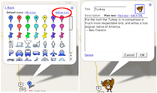
When we first started developing the map creation tools in Google Maps, I found a turkey hiding among the Maps placemark icons, a Thanksgiving leftover, no doubt. I proposed we include it in our icon menu. For some reason, no one else on the team seemed to think that was a good idea. I'm guessing few of you have been clamoring for a turkey, but perhaps you have wished for some other symbol that we neglected to include.

Today we've added support for custom icons, so now you can use any image on the web for your placemarks. Just click on the new 'Add an icon' link in the icon menu, type the URL into the dialog box, and you're good to go. I typed in http://google.com/mapfiles/turkey.png to get my majestic bird.


You can also make up your own icons. Although many image formats will work, PNGs with transparent backgrounds look best on the map. Another idea is to use photo thumbnails. Here's a map showing where some of my teammates and I come from.


As an added bonus, all the new icons you add to a map are listed under the 'My icons' tab in the icon menu, making it easy to reuse them for other placemarks.
Read More
Posted in | No comments

Previewing content in Google Earth

Posted on 12:41 by Unknown
Posted by Wei Luo, Senior GIS Specialist

You might go to Google Earth to look up something specific—your house, your next vacation spot or close-up pictures of elephants in Africa, for example. Or sometimes you might just feel like wandering the earth, diving in to find out more about a particular location or topic. But where do you start? There's so much fascinating content in Google Earth created by partners like National Geographic Magazine, the Jane Goodall Institute and NASA that it can be hard to get going. We're happy to announce that we've added a 'preview' layer, a selection of placemarks that highlight our many content layers, to help make this exploration easier. It's a new, easy way to see what's out there without getting overwhelmed.

Say, for instance, you're exploring the southwestern region of the United States, and you click on a National Geographic placemark over Arizona. And then, after reading about the Grand Canyon, you get curious about what other photos National Geographic has of the region. Just click on the 'Show this layer' link at the top of the bubble, and you'll be able to explore this area more fully.

Here's what you'd see in the National Geographic 'preview' layer:


And here's what you'd see after clicking on the 'Show this layer' link. When you're finished looking, you can click "Hide this layer" and the National Geographic icons will disappear.

Read More
Posted in | No comments

Tuesday, 18 September 2007

Every percent counts

Posted on 08:43 by Unknown
Posted by Chris Harrelson, Software Engineer, Google Transit

The Google Transit team has been busy lately. In the last few weeks alone we've added trip planning coverage for:

- Buses and light rail in Dallas, Texas
- The Las Vegas Monorail
- Humboldt County, CA
- Thousand Oaks, CA
- Bay Area Rapid Transit (BART)

I'm especially excited about this last one, since it's our first partner agency to serve my hometown of Berkeley, CA. Oh, and there's one more reason I like BART. As you may know, Google Transit began its life as a 20 percent project. Now, the fine folks at BART have furthered their collaboration with us in BART 1 percent time which is like 20 percent time, only, as our friends at BART explain, "it's one person and 19 percent less time." This data is available for anyone who wants to access it in the Google Transit Feed Specification, a creative commons-licensed data format we've developed to help facilitate sharing of data within the transit community.

There's also great news for Europe. We've added transit stop icons to Google Maps for a new batch of cities. In addition to Dublin, Ireland and Linz, Austria, the following 12 cities in Germany have also joined the club: Augsburg, Bielefeld, Bochum, Bunde, Dresden, Jena, Karlsruhe, Kassel, Lubeck, Mainz, Rostock and Trier.
Read More
Posted in | No comments

Friday, 14 September 2007

Australia readies itself for a Google Maps election

Posted on 22:01 by Unknown
Posted by Alan Noble, Google Australia

It might not be widely known to our friends in the northern hemisphere, but a federal election is due to take place in Australia before the end of the year. Nothing captures the public's attention or stirs emotion quite like an election, however, many of our citizens do not have easy access to electorate information. A recent launch in Sydney of a Google Australian election website helps to remedy this by providing Australian voters with an intimate look at the parties, candidates and election issues.


The main product for this initiative is an electorate Mapplet, which identifies which parties hold what seats, who the sitting member is and what margin they currently enjoy. It has a number of interactive features that allow people to analyze the political landscape in depth. And once the election is called, we intend to add polling booth locations and even more candidate information.

It is worth noting that this Mapplet was built with publicly accessible data using Google Pages for hosting and is something any developer could have constructed — all of the tools we used are available to the public. For more information, please view the product demo below.


Happy voting, Australia.


Read More
Posted in | No comments

Thursday, 13 September 2007

More of the world for you to explore

Posted on 19:04 by Unknown
Posted by Dave Barth, Product Manager

Here's great news for all of the virtual explorers out there: Today we added 54 new countries to Google Maps! We've more than doubled our coverage of Latin America and are now mapping three times as many countries in Asia as before. So if you've ever wanted to get the flavor of an energetic metropolis like Mexico City or scope out the relaxed vibe of a small island like Aruba, we've got you covered.

Here's the full list of new countries:
Afghanistan, Aruba, Bahamas, Bahrain, Bangladesh, Belize, Bermuda, Brunei Darussalam, Bhutan, Bolivia, Cambodia, Chile, Colombia, Costa Rica, Cuba, Ecuador, El Salvador, Fiji, Guatemala, Haiti, Honduras, Indonesia, Iraq, Iran, Jordan, Kazakhstan, Kyrgyzstan, Kuwait, Laos, Lebanon, Mexico, Myanmar (Burma), Mongolia, Nepal, Nicaragua, Oman, Pakistan, Panama, Paraguay, Peru, Philippines, Papua New Guinea, Qatar, Saudi Arabia, Sri Lanka, Syria, Tajikistan, Turkmenistan, Timor-Leste, Uruguay, Uzbekistan, Venezuela, Vietnam, Yemen

We have better detail for some countries than others, but this is just the beginning. In coming months, we'll be working tirelessly to add more detail to the existing countries in Google Maps, and we'll also be adding new countries to the list.
Read More
Posted in | No comments
Newer Posts Older Posts Home
Subscribe to: Posts (Atom)

Popular Posts

  • Helpful maps for the Inauguration
    There is most definitely a buzz in the air.  Hundreds of thousands of people are streaming into Washington D.C. to see Barack Obama sworn in...
  • Virtually experience the Inauguration
    Earlier today, we posted some tips about how to use Google Maps to be prepared for tomorrow's Inauguration. Well, for those who aren...
  • New ways to get around with the Transit Layer
    I'm pleased to announce the launch of the Transit Layer on Google Maps in more than 50 cities around the world making it easier for citi...
  • Explore the masterpieces of the Prado Museum up close with Google Earth
    Today Google launches the  Prado layer in Google Earth allowing you to explore highly detailed photographic images of fourteen of the Prado...
  • Finding that free space
    Posted by Lei Zhang, Software Engineer I live in Santa Monica, so I've spent a lot of time driving around parking lots going in circles ...
  • A new place to find help
    Our Google Map Help Group now has a new home! You may have already heard of (or tried out) the  new Google Help Forums . Today, our  Google ...
  • Street View turns 1, keeps on growing
    Posted by Jiajun Zhu, Software Engineer To celebrate Street View's one year birthday, I am very happy to announce we are bringing Street...
  • Don't let history pass you by
    Back in November we launched the  Ancient Rome in 3D Curriculum Competition  alongside a brand-new  Google Earth layer  highlighting the his...
  • Share questions & answers in the Google Earth Help Forum
    Earlier this week, we told you about the new Help Forum for Google Maps . Well the Google Maps enthusiasts aren't the only ones who wil...
  • Super day for a super map
    Posted by Brittany Bohnet, Elections Program Manager We've done it before and we're doing it again, this time in a much bigger -- da...

Categories

  • gadgets
  • Map Maker
  • Mobile
  • Outreach
  • Quiz
  • real estate
  • Street View
  • Tip of the week
  • Transit

Blog Archive

  • ▼  2009 (11)
    • ▼  January (11)
      • Virtually experience the Inauguration
      • Helpful maps for the Inauguration
      • Share questions & answers in the Google Earth Help...
      • Don't let history pass you by
      • A new place to find help
      • New ways to get around with the Transit Layer
      • Explore the masterpieces of the Prado Museum up cl...
      • Flying Through Google Earth at Macworld
      • Google Street View helps find kidnapped Mass. child
      • Geotagging blog posts
      • Building a bridge in Google Earth
  • ►  2008 (257)
    • ►  December (17)
    • ►  November (16)
    • ►  October (27)
    • ►  September (33)
    • ►  August (16)
    • ►  July (20)
    • ►  June (17)
    • ►  May (25)
    • ►  April (30)
    • ►  March (16)
    • ►  February (25)
    • ►  January (15)
  • ►  2007 (137)
    • ►  December (19)
    • ►  November (27)
    • ►  October (26)
    • ►  September (13)
    • ►  August (14)
    • ►  July (13)
    • ►  June (11)
    • ►  May (14)
Powered by Blogger.

About Me

Unknown
View my complete profile